Comments Due Tomorrow, Nov. 25, on Revised Draft Update to County Well Ordinance.
Comments on the revised draft version of the 2014 update to Ventura County’s Well Ordinance No. 4184 are due by Tuesday, November 25. The County incorporated several revisions as a result of comments received at last week’s workshop on the draft ordinance.
Send comments to Rick Viergutz at rick.viergutz@ventura.org, or 805/650-4083.
Revised Ordinance
Exhibit 1 – Flowmeter Calibration Procedures
Dec. 11 Watershed Council Meeting
The next meeting of the Ventura River Watershed Council will be on Thursday, December 11, 2014, from 9:30 am to 12:00 pm, in the Topping Room of the Foster Library, 651 E. Main Street.
Look for an agenda later in the week.
Asian Citrus Psyllid Treatment Moves to “Area Wide Management”
in Santa Clara River Valley
As was discussed briefly at last week’s Council meeting, treatment for the Asian Citrus Psyllid (an insect which spreads a lethal citrus disease) is moving to “Area Wide Management” in the eastern Santa Clara River Valley, our neighboring watershed. Here is a link to an announcement about that strategy.
Again, NOW is the time to remove neglected citrus trees in our watershed. Let’s mobilize and do what we can to prevent the need for this level of treatment. Please spread the word!
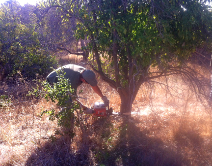
Here is a shot of the Ojai Valley Land Conservancy’s field crew getting started today on removing orange trees in an abandoned orchard on the Ventura River Preserve. Thank you OVLC!!
Rain or No Rain, That is the Question
The following information on this winter’s weather outlook is from local researcher Al Leydecker, PhD. If you’d like your email address added to his list to receive his occasional technical articles on the watershed, send a note to al.leydecker@cox.net.
The 3-month Weather Bureau rainfall outlook shows “equal chances” for our area. What this means in practical terms—if we extend the forecast to cover our whole rainy season (usually longer than 3 months)—is that we have a 1 in 3 chance of a low rainfall (less than 13 inches in Santa Barbara and Ojai, less than 10.5 inches in Ventura), a 1 in 3 chance of a normal rainfall year (13 to 21 inches in Santa Barbara and Ojai, 11 to 17 inches in Ventura), and a 1 in 3 chance of higher than normal rainfall (over 21 inches in Santa Barbara and Ojai, over 18 inches in Ventura). If we look at the map a little cross-eyed and put ourselves in the light green portion these probabilities change to a 40 percent chance of higher than normal rainfall, a 33 % chance of normal rainfall, and only a 27 % chance of a dry winter. And how dry might a dry winter be? In 2007 Ojai and Santa Barbara got only 7 inches, and in 1990 a little less than 5 inches fell in Ventura (this was noticeably worse than the lowest rainfall year of our current drought—2013—by 2-3 inches). (For more information: http://www.cpc.ncep.noaa.gov/ )
The National Weather Service bases their estimates of what is above and below normal and normal on the rainfall that occurred from 1981 through 2010. During those years the average for Santa Barbara was 19.5 inches while the median (half the years had less rainfall than this, half had greater) was 17.5. For Ojai the corresponding numbers are 21 and 18 inches; for Ventura 16 and 14. Notice that the median rainfall is lower than the average—in other words, more of our years are below-average than are above, and we should expect a “normal” year (whatever that might mean) to be below average.
As for El Nino, the Weather Service states that “ENSO-neutral conditions continue” and their prediction is “a 58 percentage chance of El Nino during the Northern Hemisphere winter which is favored to last into the spring of 2015.” So there’s still a chance of an El Nino winter, but it’s no longer that big 1998-like blowout they once talked about. I’ve attached a chart of the various ENSO (El Nino-Southern Oscillation, the more formal name given to the El Nino/La Nina climate variation) and I’ve drawn a heavy red line at the El Nino boundary: I’ll skip the details, all you have to know is that a temperature anomaly above 0.5 degrees Centigrade (which means sea temperatures in the eastern Pacific a half a degree Centigrade above normal) puts us in El Nino territory (if it stays there for 5 seasons it officially becomes an El Nino). (For more information see http://www.cpc.ncep.noaa.gov/products/analysis_monitoring/enso_advisory/index.shtml And for those really interested I recommend Jan Null’s webpage http://ggweather.com/enso.htm )
Notice that not every organization (the list is off on the right side) says it’ll be an El Nino—a couple think we’re headed for La Nina—but a majority of them do. But the size of the temperature anomaly is predicted to be low: most of the predictions are in the 0.5 to 1.0 degree range. To put that into perspective, our real big “El Nino” winters resulted from very large temperature anomalies: 2.2 degrees in 1983 (giving us 43 inches of rain at Ojai), and 2.4 degrees in 1998 (49 inches of Ojai rain). Low temperature anomalies give us weak El Ninos, like the 1.3 degrees in 2003 with 20 inches of Ojai rain, and 1.6 degrees with 24 inches of Ojai rain in 2010. Note that these rainfall amounts are pretty close to the Ojai average (21 inches). Indeed, while there is a good relationship between strong El Ninos and increased rainfall for our region, there is almost no relationship between rainfall and a weak El Nino.
There is slightly better news from the Weather Bureau’s longer range prediction. They’re looking at a greater chance of above normal rainfall (around the 40% chance mentioned above).
For that prediction, and for those who’d rather listen and watch than read, you can see their video here http://www.climate.gov/news-features/videos/winter-outlook-2014-2015