We Have Watershed Signs!
by Bill O’Brien, NextGen Engineering
There are many signs along the roads and the paths we wander that we can take for granted, but a new sign catches our attention. Ventura River Watershed – Keep it Clean signs are being installed at six locations from Main Street Bridge in Ventura to Ojai to catch our eye and consideration.
Part of this message is to remind us that we live in a watershed, where the waters that fall on this land then “shed” and drain into creeks that end up in the Ventura River. Many of us are learning about the watershed we live in. While we don’t pay taxes or have a zip code specific to this watershed, we live in it and use its resources. “Keep it clean”?… because it is our home and our water supply and place for recreation. If we dump anything in the storm drains or creeks, we know where it goes – into our watershed.
The Ventura Countywide Stormwater Quality Management Program (VCSQMP) installed these signs to help us know our watershed and to keep it clean. More information about stormwater and water quality in the watershed can be found at VCSQMP’s website: www.vcstormwater.org/
(Much thanks to Thanks to Arne Anselm of the Watershed Protection District, VCSQMP, and the Ojai Valley Green Coalition, which has been advocating for the signs for some time now!! -Lorraine)
Nov. 7 Watershed Council Meeting – Al Leydecker to Report on Recent Nitrate Analysis
The next meeting of the Ventura River Watershed Council will be on November 7, 2013. I’ll get the agenda out soon, but I wanted to let you know that Al Leydecker, PhD, is scheduled to provide us with a presentation on his latest research on nitrate and its possible sources in the watershed.
As many of you know, Al, who is now a semi-retired scientist, has been monitoring and analyzing stream chemistry in the Santa Barbara/Ventura area since since 2000. He was one of the authors of the UCSB algae study–“An Assessment of Numeric Algal and Nutrient Targets for Ventura River Watershed Nutrient Total Maximum Daily Loads”–which is cited, along with six other of Al’s research papers, in the staff report of the recently adopted Algae TMDL regulation.
A generous laboratory recently provided an isotopic analysis of some of Santa Barbara Channelkeeper’s stream samples; such an analysis can, in theory, help narrow down the likely sources of nitrate. Al’s presentation, entitled CSI: Ventura Watershed, will present various lines of evidence to help solve some of the mystery, including the results of the isotopic analysis. No smoking gun, but some interesting leads.
Al is still gathering bits of nitrate data for his analysis, so if you have a well in the watershed and collect nitrate data that you can share, I can pass that along to him.
The November 7 meeting will be from 9:00 am to 12:00 pm, in the Topping Room of the Foster Library, 651 E. Main Street.
Ag Meeting Presentations on Website, and Thanks for the Food!
We had five interesting presentations at the October 3 agriculture-focused Watershed Council meeting. The presentations are posted on the Council’s website if you want to take a look.
I also wanted to thank the growers who contributed food to the meeting, including the Pixie Growers Association, Churchill-Brenneis Orchards, Steve Sprinkle of Farmer and the Cook, the Ojai Olive Oil Company, Taylor Ranch (and the strawberry grower there), and Atmore & Sons.
Oct. 21 Ojai Valley MAC Meeting – Update on Standards for New Septic Systems
At the
Oil Wells
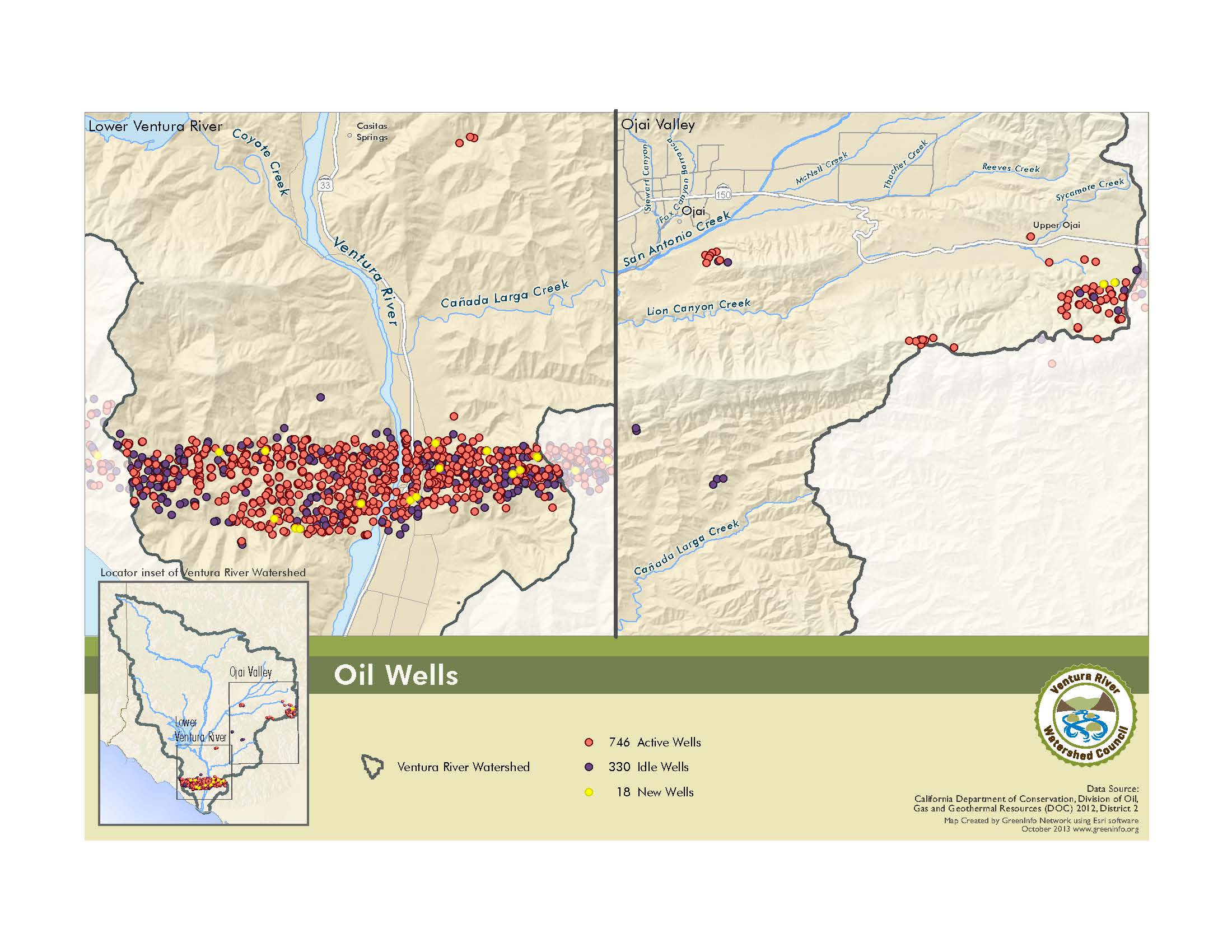
The latest addition to our Watershed Atlas is a map of the location of oil wells. This data is from the California Division of Oil, Gas and Geothermal Resources. The Transverse Ranges, of which the watershed is part, is a highly folded and faulted geologic province that has some petroleum-rich sedimentary rocks. The result is that this province is one of the important oil-producing areas in the United States. The major oil field in the watershed is the Ventura oil field, an area that covers approximately 3,410 acres on both sides of Highway 33 in the lower watershed near the coast. The Ojai oil field comprises 1,780 acres of active fields.