Sewer Lines and Septic Systems Map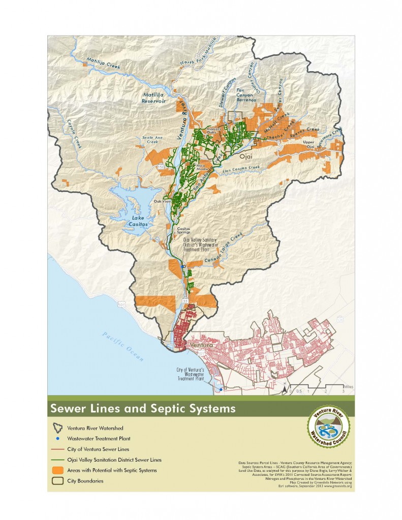
The latest addition to our Map Atlas is a Sewer Lines and Septic Systems Map. The map shows the location of existing sewer lines and wastewater treatment facilities, along with a rough estimate of where septic systems are likely located.
As with many things we’d like to map, the availability of comprehensive and up-to-date data was limited with regard to septic systems. SCAG’s (Southern California Association of Government) land use data was used in this case to show likely areas of unsewered residences and buildings. (This was one of several ways to approach the mapping, all of which had limitations.)
Thanks to Diana Engle and Larry Walker and Associates for sharing their data, as developed for their 2011 Corrected Source Assessment Report: Nitrogen and Phosphorus in the Ventura River Watershed.
Tonight (Oct. 3) – Special Agriculture-Focused Watershed Council Evening Meeting
Here is one last reminder about our agriculture-focused Watershed Council meeting tonight.
The meeting will run from 6:00 – 8:30 pm, and will be held at the Oak View Community Center, 18 Valley Road, in Oak View. Plan to come early though, because from 5:45 -6:00 pm we’ll have an eat the creek pre-meeting meet-and-mingle, which will feature some samples of the watershed’s harvest.
We’ve got some great speakers lined up, and time for discussion. Watershed Council meetings are open to anyone interested and we encourage new participants. Hope to see you there!
Here is the meeting agenda.
Last Call for Projects/Programs!
Short-Term Action Plan Project/Program List Under Development
Work is starting on the Short-Term Action Plan, one of the parts of our Watershed Management Plan. The Short-Term Action Plan will be a smaller list of projects, gleaned from our Tier 1 Project/Program List, that can be achieved in the short-term.
A project/program screening process will be used to distill our large Tier 1 List down to the smaller Short-Term Action Plan List. Tomorrow, October 4, I’ll be sending project/program screening instructions to those organizations, listed below, who already have projects on our Tier 1 List.
If your organization is not listed below, but you would like to have projects or programs included in the Ventura River Watershed Management Plan, please get in touch with me soon so we can get your projects/programs added. The current Tier 1 List can be found on the Watershed Council website.
California Coastal Conservancy
City of Ojai
City of Ventura
County – Parks
County – Planning Division
County – Environmental Health Division
County – Public Works
County – Watershed Protection District
Regional Water Quality Control Board
California Fish and Wildlife
Casitas Municipal Water District Ventura Water
Meiners Oaks Water District
Ventura River County Water District
Ojai Basin Groundwater Mgmt. Agency
Ojai Valley Sanitary District
California Conservation Corps
Ojai Valley Land Conservancy
Resource Conservation District
Trust for Public Lands
UC Cooperative Extension
Ventura Hillsides Conservancy
Friends of Channel Coast State Parks
Matilija Coalition
Ojai Valley Green Coalition
Santa Barbara Channelkeeper
Surfrider Foundation
Ventura River Watershed Council
Friends of Ventura River
Ventura County Coalition of Labor, Ag. and Business
Oct. 12 is Farm Day!
Passing along this announcement. Several of our watershed’s farms are featured in this event.