Dec. 13 Watershed Council Meeting Agenda
Below are links to the meeting agenda and related materials for our December 13 Watershed Council meeting. We will reviewing, and hopefully approving, the final recommendations for our watershed management plan’s goals and objectives. We’ll refine an assessment of our watershed’s vulnerabilities to climate change. The UCSB Bren students will provide us with an update on their student project focused on a water budget for our watershed and they will take input on their project thus far before beginning their final analysis. We’ll hear updates from the Watersheds Coalition of Ventura County, and also hear the latest on the algae TMDL and pumping/diversion impairments.
The meeting will be held in the Topping Room of the EP Foster Library, 651 E. Main Street, Ventura, and will run from 9:00 am to 12:00 pm. Don’t miss the group photo (for our watershed management plan), which will be taken at the beginning of the meeting.
Meeting agenda materials:
Agenda
Final Recommended Goals
Guiding Values – Recommended Update
The final recommended objectives will be sent out next Monday, December 10.
HEAR YE! HEAR YE!
OUR ITEM AT THE REGIONAL BOARD HEARING TOMORROW (DEC 6)
WILL NOT BE HEARD UNTIL AFTER LUNCH!
Jenny Newman, Unit Chief with LA Regional Water Quality Control Board (RWQCB), just let us know that our TMDL item on tomorrow’s RWQCB hearing agenda will not be heard until after lunch. Our item is number 17 on the agenda, so this is good to know. The hearing officially begins at 9:00 am and will take place at the city of Simi Valley, Council Chambers, 2929 Tapo Canyon Road, Simi Valley.
Also, on December 4, 2012, the RWQCB sent out an email announcing additional proposed changes. They included a “Change Sheet” which summarizes the most recent changes and the reason for the changes. They also sent out the second, revised proposed Basin Plan Amendment, which shows these new changes highlighted in red.
The latest changes include the following:
- Addition of a new section and requirements for grazing activities.
- Extending the due date for water monitoring for horse/intensive livestock activities to 10 years from adoption of the TMDL.
- Clarification of language regarding waste load allocations for the Ojai Valley wastewater treatment plant.
- Addition of language regarding waste discharge requirements for horse and intensive livestock activities.
Here also is a link to the RWQCB’s webpage for all the background documents on the Algae TMDL. And here is the full agenda.
The contact person at the RWQCB is Jenny Newman, (213) 576-6691.
An Assessment of our Watershed’s Climate Change Vulnerability
Lynn Rodriguez, Watersheds Coalition of Ventura County project manager, and I are in the process of developing an assessment of our vulnerabilities to climate change, which will be included in the update to the Integrated Regional Water Management Plan (IRWMP), as well in the Ventura River Watershed Management Plan.
We’ve completed a rough draft of this vulnerability assessment and we’ll be reviewing this at our December 13 Council meeting. We are looking for your input on this assessment. The more input we can receive before the meeting, the better.
Here are the background documents:
Memo explaining the assessment.
Excel file which contains the assessment. (This file may not open automatically, but it should download.)
Please email me with your comments by December 12, or come to next week’s meeting and share your comments with the group.
Al Leydecker’s Report from the River
Al Leydecker, Ph.D., Channelkeeper’s technical advisor for the last 11 years, gave the following report on his visit to the Ventura River and San Antonio Creek with the Ventura Stream Team last weekend. I know I was wondering how much rain it takes before we start to see water flowing in the river. Thanks to Al and the Stream Team for this good information and the photos.
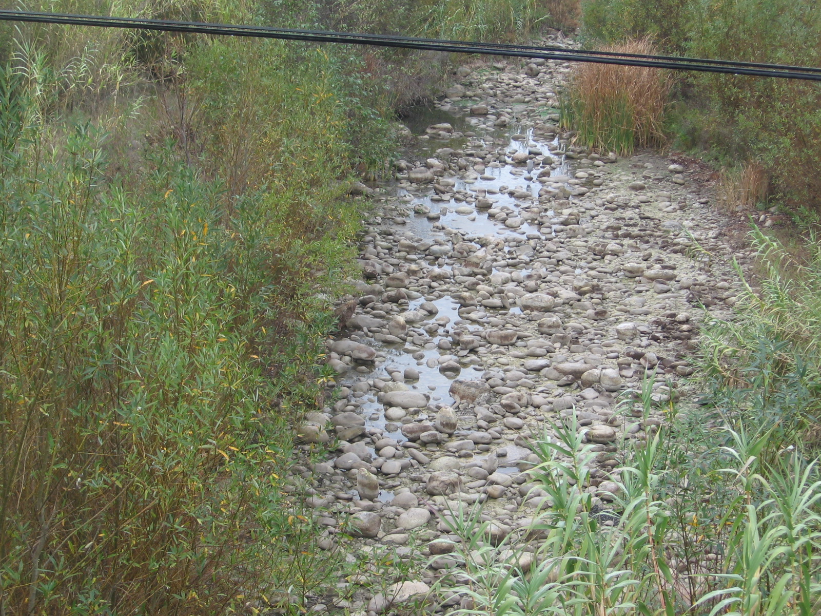
Foster Park, December 1, 2012. No flow, but a few puddles from recent rains.
https://www.dropbox.com/sh/wk5iy9q6ntl42x3/zbq067nnng
“This is the link to the photos I took yesterday for Ventura Stream-team. The river is still dry; it takes over 5 inches of closely spaced rainfall to get things flowing after our long dry season (consider the parched soil as a giant dried-out sponge) and we’ve only had about 3 inches in the last month or so. The recent rains have not increased flow over what was seen last month.”
“The river, from the mouth of Matilija Canyon to the Ojai wastewater treatment plant is dry – except for the occasional reach where it intercepts some groundwater flow. The lower San Antonio and the area at the San Antonio confluence is bone dry (which often happens at the end of a long dry season) and Foster Park remains dry (which has never happened before in my experience – which goes back to 2000).”
“The lagoon level is up due to a rather solid and firmly emplaced sand berm; however it is obviously overtopped by high tides and the mixture of salt and fresh water is probably creating some interesting conditions in the lagoon.”
Atmospheric-River Megastorms
The article below, written by Nat Seavy, is from an email sent out this week by the California Landscape Conservation Cooperative Alliance ListServe. Some sobering information about climate change and flood risk in California. At our February 2013 meeting, Brian Trushinski from the Ventura County Watershed Protection District, will provide a presentation on the District’s recent modeling of these sorts of megastorms in our area.
On account of our recent weather, Scientific American is providing an early (and free) release of an article on atmospheric rivers that is scheduled to run in January 2013. The article is authored by Mike Dettinger (USGS) and B. Lynn Ingram (UC Berkeley). It is a fascinating article.
The article describes the conditions that created flood of 1861-62, which was created by an atmospheric river that brought rain to California beginning on Christmas Eve 1861 and continued almost continuously for 43 days. The article then puts this storm in the context of geological evidence for similar storms and how they might change as the Earth’s atmosphere warms. Here are a couple of quotes that I found particularly interesting:
“Sediment cores taken from beneath San Francisco Bay itself also indicate that in 1400 the bay was filled with freshwater (as it was during the 1861–62 event), indicating a massive flood.”
On climate model projections: “All seven models project that the number of atmospheric rivers arriving at the California coast each year will rise as well, from a historical average of about nine to 11. And all seven climate models predict that occasional atmospheric rivers will develop that are bigger than any of the historic megastorms. Given the remarkable role that atmospheric rivers have played in California flooding, even these modest increases are a cause for concern and need to be investigated further to see if the projections are reliable.”
“Scientists who recently modeled a similarly [to the storm of 1861] relentless storm that lasted only 23 days concluded that this smaller visitation would cause $400 billion in property damage and agricultural losses.”
“The costs are about three times those estimated by many of the same USGS project members who had worked on another disaster scenario known as ShakeOut: a hypothetical magnitude 7.8 earthquake in southern California. It appears that an atmospheric-river megastorm—California’s “Other Big One”—may pose even greater risks to the Golden State than a large-magnitude earthquake.”